Neolithic Tors in West Penwith
This page is a sample page for this 'Penwith Sites' part of the Belerion site. The rest will follow in due course.
On other Pages
In preparation!
General resources:
Interesting Stuff
Useful reading:
Tor Enclosures
The oldest constructed sites in Penwith
www.ancientpenwith.org/tors.html - all about Tor Enclosures.
www.ancientpenwith.org/pics2-neolithic-tors.html - picture tour.
www.palden.co.uk/shiningland/prehistory05-neolithic3000s.html - a history of the Neolithic in Penwith.
Carn Galva
The Lookout Carn. SW 4256 3639. 50.171456 -5.6067374. Map: Carn Galva. Heritage Gateway. Giants. Meyn Mamvro.
In the forested ‘true Neolithic’ of the 3000s BCE this was the centre of everything, sticking out of the wildwoods. Perhaps half of Penwith’s then population of, say, 2,000 souls, lived within two miles of it. This twin-peaked dragon-tor, with fine views, acted as an axis mundi for Penwith - the centre of the Penwith world. It presents a different shape from different directions.
Mên Scryfa with Carn Galva behind.

Carn Galva and Zennor Hill lay at the centre of Neolithic life in early Penwith, in the highlands – the place to be in the warm climate of the time.
Carn Galva looks and feels prominent - a true 'magic mountain'. Neighbouring Watch Croft is higher, but Carn Galva looks higher - one's eye is drawn to it. It is a hub, a centre of gravity or omphalos (Greek for 'navel') for Penwith, lying at the centre of the originally populated upland area in the north.
The southern peak has a double hump, seen side-on. Seen end-on from Nine Maidens and the south, Galva looks more like a rounded pyramid. Quite a few propped and placed stones have been found by Kenny Price on the tor, from a similar time to the building of the enclosure. In its heyday it did not look as stark as today, and it would rise majestically out of the trees and scrub below, hovering above the treescape.
Research suggestions: 1. Energy centres and energy-field features? 2. Astronomical alignments; 3. Propped and placed stones; 4. Azimuths of other visible sites; 5. One advantage here is that you can tune into Neolithic reality without many extra time-layers on top; 6. Apparently it’s possible to see the tops of the mountains of Ireland from here.
Carn Kenidjack
SW 3879 3297. 50.139141 -5.6569923. Neolithic tor enclosure and the oldest site in the Tregeseal complex. Map: Carn Kenidjack. Meyn Mamvro. Heritage Gateway.
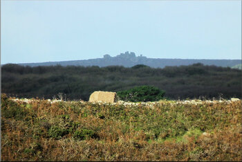
Carn Kenidjack from a geomantic cairn near Carn Lês Boel (find it!)
Daunting and characterful, not very high, visible from many points in West Penwith and from the Scillies, and presenting a broody, mysterious character. Its rocky granitic outline, including two simulacra, is noticeable, rather archetypal in form.
Known as the Hooting Tor, owing to occasional wind effects during gales on dark, forbidding nights, it later became the overlighting landscape setting for the stone circle at Tregeseal just below, as did Carn Galva for the Nine Maidens. These stone circles were built later in the Bronze Age when the centre of gravity and attention moved down from the tors to the stone circles.
Research suggestions: 1. examine for propped and moved stones and simulacra, 2. Where’s the main energy-centre(s)? 3. Check azimuths of visible sites in landscape; 4. Visualise how it was in a forested landscape; 5. What is it geologically and energetically that makes a tor a tor, recognised as a power place by the very first inhabitants?
Trencrom Hill
Tor Crom. SW 5172 3625. 50.174144 -5.478555. Neolithic tor enclosure and Iron Age hill camp, with holy well. Map. Historic England. Heritage Gateway.
 A lovely summer residence for a small tribe, with a flattish top for dwellings and human activity, a hilltop spring and fine views. It was reoccupied as an Iron Age hillfort, when many Neolithic remains would have been recycled. A day's walk from Carn Brea, trackways will have branched from Trencrom toward the Zennor uplands, Castle an Dinas and southern Penwith.
On the eastern edge of the peninsula, it has spectacular views over both the north and south coast, with a fine view east to Carn Brea. Trencrom looks imposing from the east, acting as a guardian or gateway hill for Penwith. St Michael's Mount, Trencrom Hill and St Ives Head mysteriously align with each other, forming the eastern energy-threshold of the Penwith peninsula.
Trencrom is worth a climb on a nice day. Try finding the old spring near the summit. It was not, or hardly ever, a defensive site, but it was indeed a stronghold, giving a sense of territoriality and identification with the landscape. People had a feeling for their land and its place under the heavens when on top of the hill - not in the sense of owning it, but more in the sense of identification with it as their homeland.
Research suggestions: 1. Check azimuths of major landscape features visible from Trencrom; 2. Check energy-patterns on the top of the hill and around the well. 3. Where’s the power centre(s)? 4. Check difference between the Neolithic and Iron Age layers. 5. Get a feel of the people who lived there, and their lives. 6. Check astronomicals.
St Michael's Mount
Carrek los y'n cos (Grey rock above the woods). SW 5143 2984. 50.117048 -5.477489. An island since around 1700 BCE. Major node on the Michael and Apollo lines. Neolithic tor and cliff sanctuary, with multiple historic layers. Managed by the National Trust. Map. Heritage Gateway.
 While hardly any signs of a tor enclosure remain here, the Mount is seen by archaeologists as a tor site and a cliff castle rolled into one. Clearly it is one of the most charismatic sites of Penwith, stuffed with mythic symbolism, today with its castle on top, built from the 1100s CE onwards. It is visible from many places, including the Lizard peninsula.
The Mount has had a long and varied history, not only as a Neolithic tor enclosure and cliff sanctuary but also a famous ancient and medieval trading place, a monastery, fortress, stately home and now a National Trust property.
In neolithic times it was not an island. The coast was a mile or so out to sea, and the Mount was surrounded by wooded flatlands. The remains of a submerged forest on the beach near Marazion are sometimes revealed during storms (such as 2014). It became an island during the Bronze Age around 1700 BCE - perhaps by a tsunami from Portugal or the Azores. Nowadays an island, it is linked to the mainland by a causeway at low tide.
Legend has it that Joseph of Arimathaea and Jesus visited here. Before that it was visited by a Greek explorer, Pytheas, in the 330s BCE, in Alexander the Great's time. In the Neolithic it was a rocky upstanding tor that was special to the locals. People might have lived there in summer months. If not, they certainly visited there at special times.
The Mount is an important alignment centre for the whole of West Penwith. Throughout ancient times, it was a significant trading place, particularly for tin, and a meeting point for people visiting Cornwall by sea from the European mainland.
Research suggestions: 1. Check out Hamish Miller’s dowsing work on the Mount; 2. Try to distinguish between place-memory fields from post-megalithic times, and try to gain impressions from megalithic and Mesolithic times; 3. How do tourism and NT management affect the Mount’s energy-fields? 4. Power-centres: where? 5. Can you pick up on any foreign visitors in ancient or historic times? Where from?
Carn Brea

Front, Trencrom Hill. Behind: Carn Brea. Telephoto shot.
Outside West Penwith, above Redruth, but part of the Penwith landscape as seen from Trencrom Hill, Botrea Barrows or Caer Brân. Once a major trading centre for West Cornwall, especially for arrowheads and axeheads, at the meeting place of tracks from Penwith and The Lizard. It is commonly thought that Carn Brea, occupied for 300 years, came to a violent end with fighting and burning, but this is inconclusive since its walls and water sources were inadequate for defence. It might instead have burned accidentally or in a ritual burning for cleansing or closedown (like a demolition).
It's a prominent hill and focal node in the west of Cornwall (you pass it on the A30). It's on the Michael Line, crossing southern Britain from Carn Lês Boel to Norfolk, through Carn Brea, Helman Tor and the Hurlers to Glastonbury Tor and Avebury. Radial alignments from it go to many cliff sanctuaries and other sites in Mid-Cornwall.
Research suggestions: 1. Power centres; 2. Radial alignments (see map.); 3. Astronomicals; 4. Stages of development and life-cycle; 5. How did it end? 6. Where did visitors and traders come from?
Privacy. This site uses temporary cookies to watch general trends only. We aren't selling anything, capturing, mining, passing on your data or making mailing lists. It's a public service - no strings. Any issues, please make contact.