More Maps of Ancient Penwith
More Maps of Prehistoric Penwith
These maps were made for the book Shining Land and for use in my Aha Classes and other talks, using maps on the preceding page as base material. They focus particularly on the Neolithic and Bronze Age - the Megalithic period.
Can be viewed on a phone screen, but they're best viewed on a computer screen
Cornwall topography
In the Neolithic 3000s BCE, most of the action happened in Penwith, Bodmin Moor and around the coast. The Neolithics particularly liked the granitic uplands of Cornwall - and the climate was warmer, and the hilltops and coasts were the best place to be. The rest was densely and quite endlessly forested. The best way to travel any distance was by boat.

Main Neolithic sites
The main centres were Neolithic Tor Enclosures and Cliff Sanctuaries. The local tors were Carn Brea, St Michael's Mount, Carn Galva, Carn Kenidjack and Trencrom Hill. The centre or axis mundi of the Neolithics' universe in Penwith was Carn Galva. Cliff sanctuaries played a key part in the location of Neolithic and Bronze Age sites.

Penwith topography
In the Mesolithic (5000s-4000s BCE) people recognised special places with a sense of energy and magic, but they didn't build constructed ancient sites - unless perhaps they were of wood. But around 3700 new migrants entered from Biscay bringing the idea of constructed sacred spaces - shrines and areas designated as human-ruled and special. Most people lived on the hills in the north - the south was colonised in the Bronze Age.

Early Neolithic sites
These were focused around hills and cliff sanctuaries, and here are the main hills and bumps of Penwith that the ancients would have noticed and revered. In the Neolithic, most of the land was forested, but there were cleared areas where people lived, farmed and grazed livestock. Mostly they were transhumant gatherer-fisher-hunters with some horticulture, migrating around their patch through the year, though their thinking was nevertheless quite sophisticated.

Base Sites
If you came to a virtually unpopulated Penwith 6,000 years ago or more, and you ranged around the peninsula, these are the natural sites you would probably notice and take note of. These sites form the basis of the distribution of ancient sites in Penwith.

Neolithic Sites
These were built in the 'true Neolithic' 3000s between 3700 and 3200 BCE, and they were the first constructed sites in Penwith. These are the Neolithic Tor Enclosures, Quoits and Cliff Sanctuaries. The Neolithics also set up a variety of propped and placed stones (not marked).


Megalithic Timeline
This timeline shows the approximate peaks and troughs of the Megalithic era in Penwith, and the sequence of construction of ancient sites - as far as we know. Signs of activity during the fallow period from 3200 to 2500 are scanty-to-absent, but more research needs to be done into dating ancient sites, to check this.
Penwith's main megalithic sites
Penwith has hundreds of sites, but these are the main ones. In Penwith and across Britain the megalithic era came in two phases: the Neolithic (3700-3200 BCE) and the Early-to-Mid Bronze Age (2500-1200 BCE).

The Eureka Moment
I found that an alignment from St Michael's Mount to Cape Cornwall went right through the barrows on Botrea Hill, just above my house. It led me to look at alignments involving cliff sanctuaries and tors, and I made a big discovery concerning the layout of ancient sites in Penwith.
The line divides two distinct areas in Penwith - the northern uplands of the Neolithic and the southern lower lands colonised in the Bronze Age. The white patches are relatively empty areas with fewer ancient sites - probably still wild-wooded in the Bronze Age.

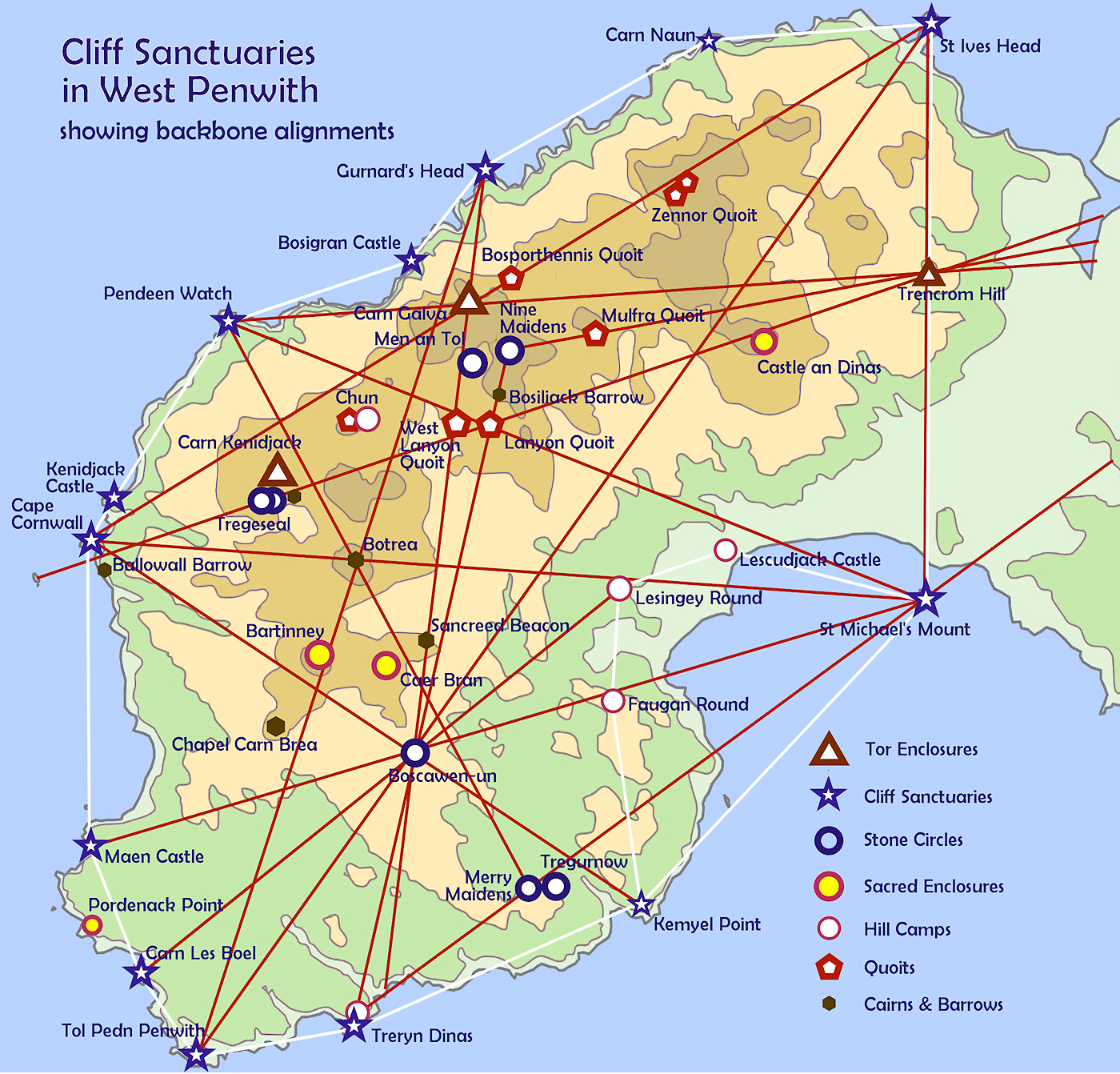
Discovering the Backbone Alignments
These involve Neolithic cliff sanctuaries and tor enclosures, plus one or more Bronze Age sites, such as stone circles.
The lines on this map demonstrate three things: 1. Lanyon Quoit was located in relation to cliff sanctuaries and tors, 2. these backbone alignments were established in the Neolithic 3000s, 3. the cliff sanctuaries were key sites in the Neolithic (usually they're dated to the Iron Age).
They suggest that some Bronze Age sites (like Boscawen-ûn, the Merry Maidens and Nine Maidens) were known in the Neolithic, even if nothing was built there.

Quoit Alignments
The quoits, built around 3700-3500, were built in the area where most Neolithics lived, arranged in a system with astronomical alignments and parallels. They experimented with an integrated landscape system.
The quoits were probably all built within a generation or two. They were built to be energy-chambers used in healing, initiation, treating seeds and tinctures, and even for dying in. But not burial. There are signs that two (Mulfra and Zennor Quoits) were deliberately decommissioned.

How it all starts knitting together
Take a good look at this map. This demonstrates how the major sites of the Bronze Age were located on the basis of the key Neolithic sites, and they were also geomantically rooted in the landscape. This was not a pattern imposed on the land, but derived from it and giving shape to the constructions of the Bronze Age. They were building a whole, landscape-wide system - one big cliff sanctuary - in Penwith. And it was a good place to do it, with clear boundaries.
The Ring of Light
The cliff sanctuaries and the three hill camps overlooking Mount's Bay form a protective 'ring of light' around the peninsula - they're the liminal boundaries of the peninsula as a complete landscape. This is what makes it a 'radiant land' (Belerion) and, arguably, it can be construed that it is a key reason why Penwith has never been invaded.

St Michael's Mount alignments
St Michael's Mount is a key power centre in Penwith with multiple alignments. It's a natural site enhanced over the millennia by (very varied) human use, as a sacred place, a settlement, trading place, monastery and fortress. Note its relationship with other cliff sanctuaries. The Mount also has two global great circle alignments going through it - the Michael and Apollo lines.

Boscawen-ûn alignments
Boscawen-ûn is not placed in what seems like an obvious place in the landscape, but the geomancy of this stone circle makes it a master-stroke that was put there to light up the whole system. Look at the way its position sits remarkably in relation to other natural sites in Penwith. It's a stone circle for Penwith but also it is of national significance.

Trencrom Hill alignments
Trencrom Hill, a Neolithic tor enclosure and Iron Age hill camp, is an energy-gateway into Penwith. It is a guardian hill together with St Ives Head and St Michael's Mount - mysteriously aligned with each other, even as natural hills. This nearly north-south alignment is the energy-boundary of the magical landscape of Penwith.

The Alignments System of West Penwith
Penwith can be regarded as one big ancient site or cliff sanctuary, roughly 10 x 15 miles in extent.
It's a cliff-contained landscape, easy enough to range around on foot in ancient times, within a few days.
Click here for the full, detailed Google map (it contains info about each site if you click on any symbol on the map).

Local Alignments
These are exact shorter-distance alignments connecting particularly Bronze Age sites - ninety of them were first identified by John Michell 50 years ago. There's an amazing number of them. To see a fully detailed Google map, click here.

Backbone Alignments
These are regional and longer-distance alignments crossing Penwith, many leading upcountry or to Scilly. These are based on cliff sanctuaries and Neolithic Tors. They determine the locations of many Bronze Age sites, giving structure to the whole megalithic system in Penwith.

NEAR-PARALLEL ALIGNMENTS
The parallels crossing the peninsula could mark an astronomical orientation. Note the other near-parallels. Their intention is yet to be understood. Click for a detailed map.
Key: | ^ Neolithic Tor | * Cliff Sanctuary |
• 123.0°. Cape Cornwall* - Boscawen-ûn - Kemyel Point*.
• 124.0°. Pendeen Watch* - Chûn Castle - Lesingey Round - Lizard Point*.
• 123.5°. Bosigran Castle* - Carn Galva^ - St Michael’s Mt^ - Pollurian Head*.
• 122.0°. Gurnard’s Head* - Castle an Dinas - Porthleven Head - Carrick Lûz*.
• 121.5°. Trendrine Cairns - Trencrom Hill^ - Godolphin Hill - Three Brothers of Grugwith quoit.
• 121.3°. Carnsew - two barrows - Bonallack Barton - Tremayne Barrow - Dean Pt*.
• 119.5°. St Ives Head* - a succession of seven barrows.
• 118.2°. Trevarnon Round - Maen Tol - Rosemullion Head*.
• 120.0°. Crane Castle* - Carn Brea^ - Stithians Moor menhir - Pendennis Point*.

Some conjectural, experimental maps...

Ancient Trackways in Penwith
This is a part-conjectural and part-evidence based map of ancient trackways. These were not geomantically based - they're practical, taking routes that people naturally followed when crossing the peninsula. Detailed Google map here.
Below: Notional Landscape Temples and Clan Areas
This map is speculative, based in observation of the lay of the land and the likely areas that each acted as a landscape temple. It's possible that each clan had each of these areas as their own patch. They were interrelated, and the boundaries between them were not guarded and demarcated, and they were less important than the key sites and centres within them.
Over the centuries there would have been many changes to the spread, relations and circumstances of Penwith's clans, but the landscape temples' structures are likely to have remained quite consistent.

Bronze Age Wildwoods
In the mid-Bronze Age, population had grown and, after 600-700 years of cultural upswing, about 50% of Penwith was forested. This conjectural map shows what this might have looked like. It's based on the hypothesis that the areas where there were fewer ancient sites and settlements were probably those where the woodlands were.

Some extra maps of interest...


Mystery Sites and their alignments
Alignments emanating from two destroyed sites - Tregurnow stone circle and the stone circle or enclosure, or something, at Trevorian - and one site, the purpose and antiquity of which is unknown - Treen Common Circle.


Prehistoric Sites across Cornwall
For a full, detailed version on Google Maps, click here.

A shortlist of ancient sites in Penwith
Making a shortlist of forty ancient sites in Penwith is surprisingly difficult! To demonstrate this, here is a list of seventy sites. There are bound to be people who would prefer to add sites (such as holy wells) to this list rather than remove sites from it - and justifiably so. However, for practical reasons, giving proper attention to seventy sites is unlikely to be doable - and it's better to do small things well than big things badly. It might be that the list needs cutting down even to a well-chosen thirty sites.
Tor Enclosures CARN GALVA CARN KENIDJACK TRENCROM HILL ST MICHAEL'S MOUNT Quoits BOSPORTHENNIS CHÛN LANYON MULFRA SPERRIS WEST LANYON ZENNOR Cliff Sanctuaries BOSIGRAN CASTLE CAPE CORNWALL CARN LÊS BOEL GURNARD'S HEAD KENIDJACK CASTLE MAEN CASTLE PENDEEN WATCH ST IVES HEAD TOL PEDN PENWITH TRERYN DINAS Stone Circles BOSCAWEN-ÛN MÊN AN TOL MERRY MAIDENS NINE MAIDENS TREGESEAL E & W Tregurnow | Circular Enclosures BARTINNEY CASTLE CAER BRÂN CASTLE AN DINAS PORDENACK POINT Hill Camps CHÛN CASTLE LESINGEY ROUND FAUGAN ROUND LESCUDJACK CASTLE Treen Circle Cairnfields Beacon Barrows Botrea cairnfield Chapel Carn Brea Foage cairnfield Mulfra barrowfield Cairns & Barrows Ballowall Barrow Boscregan Cairns Bosiliack Barrow Botallack Common Brane Cairn Chapel Carn Brea Mayon Cliff cairns Pennance Pordenack SANCREED BEACON Treen WATCH CROFT | Menhirs Boswens Carfury Drift menhirs KEMYEL-SWINGATE menhirs Mên Scryfa Pipers Fogous Boleigh Carn Euny East Bosporthennis Higher Bodinnar Lower Boscaswell Park Vorn Pendeen Vau Queried Sites Higher Trevorian - possible stone circle Giant's Grave - possible quoit Grumbla Cromlech - possible quoit Rosemergy - possible stone circle Treen Common Circle |
Resources:
Ancient Penwith. Resource website about the geomancy of West Penwith
Shining Land - the ancient sites of West Penwith and what they say about megalithic civilisation. Online book.
Palden's Prehistory Pods. Podcasts at and about local ancient sites
Maps of Penwith, Scilly and Prehistoric Cornwall. Online ancient site maps and alignments.
Ancient Penwith Picture Tour. An intro to the different kinds of ancient sites in Penwith.
Meyn Mamvro Archive. Archive of the first 100 copies of Meyn Mamvro, 1986-2019.
Cornish Ancient and Holy Wells. Maps and details of all known wells in Cornwall.
Radiation at Penwith's Ancient Sites. Map showing radiation counts at various sites
CASPN - Cornish Ancient Sites Protection Network. Monthly maintenance clear-ups of local sites (join in!).
Cornwall Council Interactive Map. Showing all known archaeological finds in Penwith.
Heritage Gateway. Online archaeological records of ancient and historic sites.
Previous: See the Maps of Cornwall
Or, for an interesting talk: Belerion, the Shining Land
Privacy. This site uses temporary cookies to watch general trends only. We aren't selling anything, capturing, mining, passing on your data or making mailing lists. It's a public service - no strings. Any issues, please make contact.