Why are Ancient Sites Aligned?
About Alignments
Ancient sites are located where they are for deliberate reasons, and a range of factors is involved. On this page are details about one of those factors, and a key one: alignments. They determine the location of many ancient sites.
What are Alignments?
Boswens menhir and, in the distance, Chûn Quoit
 On the Map of Ancient West Penwith we are dealing with alignments, not with energy-lines that dowsers and sensitives pick up. These two are different and should not be confused.
An alignment is simply a series of sites that are aligned with each other. An energy-line is a detectable energy-current in the landscape connecting different sites - as identified by dowsers and sensitives.
One does not need special sensitivities to identify alignments since they can be found, measured, marked and compared on maps. The data are reproducible and verifiable.
Ancient sites were located very deliberately, not just randomly in pleasant places or wherever their builders fancied. With a few exceptions, they are almost always aligned with other sites, and these alignments are decidedly accurate and intentional.
They are not pathways or trackways, and only in some cases (perhaps 20-30%?) are sites visible from other sites with which they are aligned, so sites cannot be interpreted as simple way-markers on alleged trackways. Ancient trackways in Penwith are neither straight, nor do they follow alignments. So while alignments are often called trackways, they aren't. (In some parts of Britain, such as Herefordshire, there are instances of tracks following alignments, but this is not so in Cornwall and generally across Britain.)
Alignments are not lines in the landscape. We draw lines on maps to show the presence of an alignment and to test its accuracy. An alignment is simply a set of sites aligned with each other, like items lined up on a tabletop.
The picture at the top of the page shows how Chûn Quoit is profiled on the local 'false' horizon, as seen from Boswens menhir (which is about a millennium younger). From the quoit, the menhir is not easily seen - so this is one-way visibility where the quoit is highlighted from the menhir but not the other way round. It's a classic example of intentional intervisibility of one site from another. So part of the reason Boswens exists is to feed attention to Chûn Quoit - though it also sits where it does for a range of other reasons too. Ancient sites such as menhirs and cairns have many reasons for being where they are.
A little history of leylines
The first known mention of alignments was by archaeologist William Henry Black in 1870, but they came to wider attention in 1921 through Alfred Watkins in his books Early British Trackways and The Old Straight Track. Later, they came to even wider attention in John Michell's seminal 1969 book View over Atlantis - historian Prof Ronald Hutton called it "...almost the founding document of the modern earth mysteries movement".
Michell sought out an area in which to do a more systematic study of alignments, choosing West Penwith and writing about it in his 1974 book The Old Stones of Land's End. (Listen to an audio talk by him here.)
After that time, ley-hunting flourished as a layperson's area of research, firmly rejected and actively and repeatedly discredited by the archaeological and academic establishments. The idea lives on because it is rich in incontrovertible evidence: the simple fact is that sites are aligned. This might not make sense, and we don't know the reasons why, yet they are aligned.
Alignments in West Penwith
Map of Alignments in West Penwith. Click for a larger version
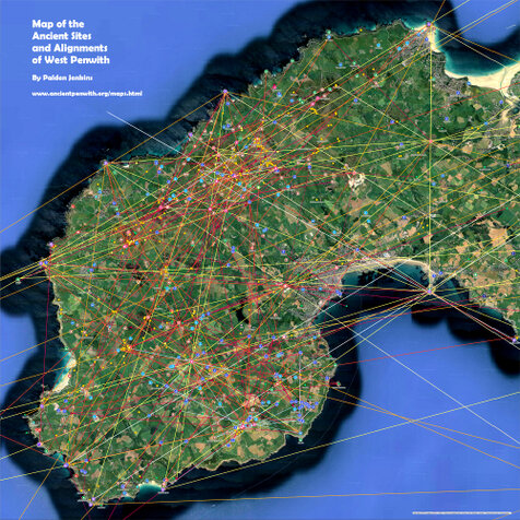
The map of ancient Penwith above shows what is known of the alignment system of West Penwith, as laid out 4,000 to 6,000 years ago in the Neolithic and Bronze Ages, with additions in the Iron Age and Early Medieval period.
The Neolithics and Bronzies had a developed knowledge in engineering, logistics, astronomy, mathematics, architecture, ecosystem and even climate management.
They had advanced beliefs and cosmology. Accessing these requires bending our modern ideas to see things more in their own way. Something intuitive, sensitive, magical, imaginal, poetic, experiential and a-rational is needed - the ancients' worldview had a logic of its own.
Three Example Alignments
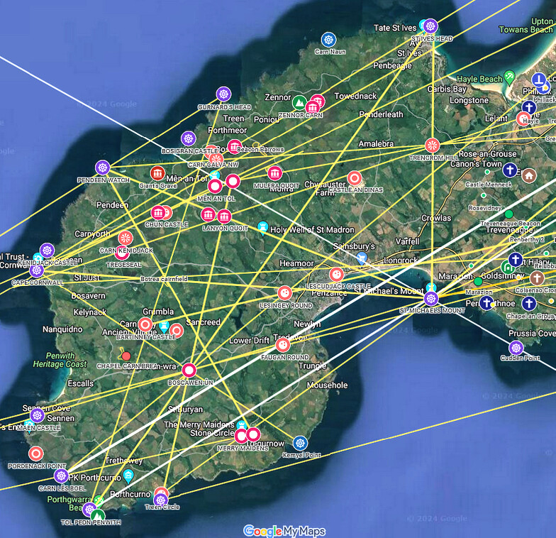
Look at the lines on the map below. These are backbone alignments, which serve as the substructure of the alignments system in Penwith. This example will give an idea of the influence they have on the location of ancient sites:
- Nine Maidens stone circle, Lanyon Quoit, Boscawen-ûn stone circle and Treryn Dinas cliff castle are all exactly aligned. These are four key sites in Penwith.
- Boscawen-ûn stone circle is aligned with St Michael’s Mount in one direction and Maen Castle and the Bonfire Carn on South Hill, Bryher, Scilly, in the other direction.
- Meanwhile, Lanyon Quoit is exactly on an alignment between St Michael’s Mount and Pendeen Watch - both of them prominent cliff sanctuaries.

By mentioning just these three alignments, the beginnings of a locational order in West Penwith begins to take shape. Sites such as Boscawen-ûn and Lanyon Quoit are deliberately placed to play a part in a wider network of alignments that are anchored to the cliff sanctuaries and Neolithic tor enclosures.
These alignments are Neolithic in origin, since the tor enclosures, Lanyon Quoit and the cliff sanctuaries are all Neolithic. The Bronze Age stone circles are located to align with these older Neolithic sites. It is possible that the site of Boscawen-ûn was known in the Neolithic, but it had nothing built on it, or it could have been a wooden structure, or whatever might have been there was upcycled when the stone circle was built.
The ancients had definite reasons for locating sites where they did. These must have been practical reasons, since the work and resources involved were enormous. They invested more in building permanent sacred sites than in permanent settlements or economic infrastructure.
How Alignments Work
Lanyon Quoit
 To demonstrate how alignments affect the location of ancient sites, let's look again at the three alignments above. They define the positions of Lanyon Quoit, Boscawen-ûn and the Nine Maidens - three key Penwith sites.
Staking down these alignments are several coastal cliff sanctuaries: St Michael's Mount, Treryn Dinas and Pendeen Watch. These are usually dated to the Iron Age around 400-100 BCE, on the basis of Iron Age 'ramparts' found at some of them.
St Michael's Mount
 These alignments suggest that cliff sanctuaries were at least Neolithic in first use, around 3700-3500 BCE.
How so? They stand on natural coastal headlands, and the three 'backbone alignments' shown on the map above, plus others, pass between the cliff sanctuaries and Neolithic tor enclosures, thus associating both with each other.
In the 3000s Britain was mostly covered in endless forest. In Penwith, tors and cliff sanctuaries were places where people could get out of the forest - thus they were important, revered and consecrated for spiritual use.
These alignments define the position of key sites such as the stone circles and Lanyon Quoit, as is visible on the map. The stone circles were built much later, around 2500-2200 BCE, but Lanyon Quoit was built around 3700-3500 BCE.
Thus the cliff sanctuaries are of a similar or greater antiquity to Lanyon Quoit, since their location defines its position. Also, the sites of the stone circles might well have been known in the Neolithic, even though their building came later.
Treryn Dinas
 Meanwhile, an alignment from Treryn Dinas to Boscawen-ûn continues through Lanyon Quoit and Bosiliack Barrow (a chambered cairn), ending exactly at a menhir (now just a stump) only yards NW of Nine Maidens stone circle.
So Lanyon Quoit's position is defined by these alignments, and also by another from Carn Brea near Redruth to Trencrom Hill (both Neolithic tors), then to Lanyon Quoit, then to the Botallack Common chambered cairn near Tregeseal stone circle.
Thus, the Bronze Age stone circles are positioned in relation to the Neolithic tor enclosures and cliff sanctuaries. Backbone alignments are thus demonstrated to be Neolithic in origin - Lanyon Quoit's location verifies this. The backbones are anchored in the cliff sanctuaries - thus they are Neolithic too.
The alignments shown above demonstrate that there is no way they are accidental, as sceptics might assert. Alignments are intentional, accurate, verifiable and evidential. There are reasons why sites are aligned, and this site and the book Shining Land explore what we can currently uncover of those reasons.
Below: Lanyon Quoit as seen from Bosiliack Barrow
looking down the alignment from the Nine Maidens toward Boscawen-ûn and Treryn Dinas

Locational Factors
Ancient sites are located where they are for a range of reasons, and these vary from site to site. What is most remarkable is the way that these different factors coincide and interact - there is a natural elegance to the way this happens. These locational factors include:
- ancient site alignments,
- astronomical orientations (to the rising and setting points of sun and moon),
- intervisibility between sites (visible sites as seen in the field),
- underground water flows (blind springs or 'water domes' and intersecting water veins),
- subtle energy patterns and lines, under and overground, arising from underground water,
- landscape placing - the topography and the visual location of sites in the landscape,
- mathematics, proportion and geometry, or megalithic science,
- sagas, narratives and myths (some of which survive today as folk-tales) and,
- spirit of place or genius loci, the 'presence' or 'soul' of a place.
These all play a part in the location of prehistoric sites in Penwith and elsewhere. They apply differently at different sites. How this works is a subject of future research. We don't understand how the megalith-builders' thinking went, but we can see signs of it in the monuments they left.
A remarkable confluence of these factors seems to determine the location of many sites. Generally, two, three or more of them seem to apply at any ancient site.
Below: Backbone Alignments in West Penwith
Click for the full Google map of backbones (untick 'long-distance alignments' to see the backbones clearly)
Privacy. This site uses temporary cookies to watch general trends only. We aren't selling anything, capturing, mining, passing on your data or making mailing lists. It's a public service - no strings. Any issues, please make contact.